
Macusani topographic map
Interactive map
Click on the map to display elevation.
About this map
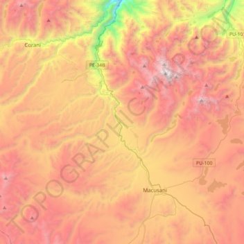
Name: Macusani topographic map, elevation, terrain.
Location: Macusani, Provincia de Carabaya, Puno, Perú (-14.14207 -70.51813 -13.80680 -70.40125)
Average elevation: 14,856 ft
Minimum elevation: 9,311 ft
Maximum elevation: 18,996 ft
Other topographic maps
Click on a map to view its topography, its elevation and its terrain.
Mulla Contihueco Hirpani
Perú > Puno > Mulla Contihueco Hirpani
Mulla Contihueco Hirpani, Provincia de El Collao, Puno, Perú
Average elevation: 12,654 ft
Virgen de Asuncion
Perú > Puno > Virgen de Asuncion
Virgen de Asuncion, Azángaro, Puno, Perú
Average elevation: 12,749 ft