Geolocate

Parwanoo topographic map

Click on the map to display elevation.

About this map

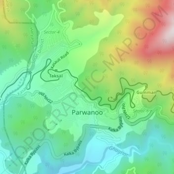
Name: Parwanoo topographic map, elevation, terrain.

Location: Parwanoo, Kasauli, Solan, Himachal Pradesh, 173220, India (30.82751 76.94496 30.85676 76.97515)

Average elevation: 2,828 ft

Minimum elevation: 1,969 ft

Maximum elevation: 4,596 ft

Other topographic maps

Click on a map to view its topography, its elevation and its terrain.

Garkhal

India > Himachal Pradesh > Kasauli

Average elevation: 5,020 ft

Kasauli

India > Himachal Pradesh > Kasauli

Average elevation: 4,117 ft

Kasauli

India > Himachal Pradesh > Kasauli

Average elevation: 4,117 ft

Gear up for your next adventure:

🪶Thermal Camp Blanket - Extra warmth for cold nights
📌Outdoor GPS Map App - Apps and devices for digital topographic navigation
📚Navigation Handbooks - Master the art of reading topographic maps and using a compass
🪓Survival Multi‑Tool - Versatile tool for camp and trail tasks
🧷Carabiner Set - Durable clips for gear attachment

As an Amazon Associate, this site earns from qualifying purchases at no extra cost to you.