
Make a donation
Gear up for your next adventure:
As an Amazon Associate, this site earns from qualifying purchases at no extra cost to you.
Kuibyshevo topographic map
Click on the map to display elevation.
Make a donation
Gear up for your next adventure:
As an Amazon Associate, this site earns from qualifying purchases at no extra cost to you.
Kuibyshevo
Kuibysheve is located on Crimea's southern shore at an elevation of 232 metres (761 ft). The settlement is located 5 km (3.1 mi) from Yalta. Its population was 62 in the 2001 Ukrainian census. Current population: 67 (2014 Census).
Make a donation
Gear up for your next adventure:
As an Amazon Associate, this site earns from qualifying purchases at no extra cost to you.
About this map
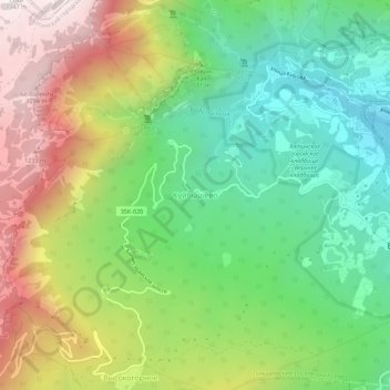
Name: Kuibyshevo topographic map, elevation, terrain.
Average elevation: 1,949 ft
Minimum elevation: 325 ft
Maximum elevation: 4,383 ft
Make a donation
Gear up for your next adventure:
As an Amazon Associate, this site earns from qualifying purchases at no extra cost to you.