
Make a donation
Gear up for your next adventure:
As an Amazon Associate, this site earns from qualifying purchases at no extra cost to you.
Garrison topographic map
Click on the map to display elevation.
Make a donation
Gear up for your next adventure:
As an Amazon Associate, this site earns from qualifying purchases at no extra cost to you.
About this map
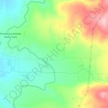
Name: Garrison topographic map, elevation, terrain.
Location: Garrison, Crow Wing County, Minnesota, United States (46.28677 -93.83847 46.31249 -93.81208)
Average elevation: 1,257 ft
Minimum elevation: 1,227 ft
Maximum elevation: 1,319 ft
Make a donation
Gear up for your next adventure:
As an Amazon Associate, this site earns from qualifying purchases at no extra cost to you.
Other topographic maps
Click on a map to view its topography, its elevation and its terrain.
Middle Cullen Lake
United States > Minnesota > Crow Wing County > Pequot Lakes
Average elevation: 1,220 ft
Borden Lake
United States > Minnesota > Crow Wing County > Garrison Township
Average elevation: 1,289 ft
Make a donation
Gear up for your next adventure:
As an Amazon Associate, this site earns from qualifying purchases at no extra cost to you.