Geolocate

Brandywine topographic map

Click on the map to display elevation.

About this map

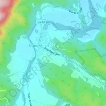
Name: Brandywine topographic map, elevation, terrain.

Location: Brandywine, Pendleton County, West Virginia, United States (38.61496 -79.24784 38.63090 -79.23411)

Average elevation: 1,713 ft

Minimum elevation: 1,522 ft

Maximum elevation: 2,493 ft

Gear up for your next adventure:

📦Gear Storage Bags - Organize and protect outdoor equipment
🪶Thermal Camp Blanket - Extra warmth for cold nights
📱Solar Portable Charger - Solar power bank for charging devices off‑grid
🧺Microfiber Travel Towels - Compact and fast-drying towels for trail use
🔭Compact Binoculars - HD vision for scouting terrain and identifying distant landmarks

As an Amazon Associate, this site earns from qualifying purchases at no extra cost to you.