
Make a donation
Gear up for your next adventure:
As an Amazon Associate, this site earns from qualifying purchases at no extra cost to you.
Paloque topographic map
Click on the map to display elevation.
Make a donation
Gear up for your next adventure:
As an Amazon Associate, this site earns from qualifying purchases at no extra cost to you.
About this map
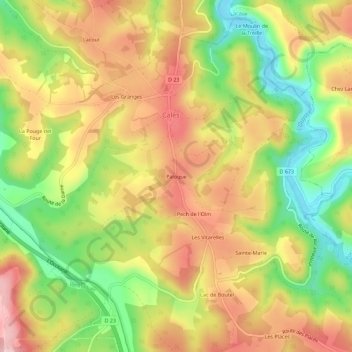
Name: Paloque topographic map, elevation, terrain.
Average elevation: 686 ft
Minimum elevation: 331 ft
Maximum elevation: 1,001 ft
Make a donation
Gear up for your next adventure:
As an Amazon Associate, this site earns from qualifying purchases at no extra cost to you.
Other topographic maps
Click on a map to view its topography, its elevation and its terrain.
L'Ouysse
France > Occitanie > Lot > Calès
L'Ouysse prend sa source dans le nord du département du Lot, en limite des communes d'Anglars et Lacapelle-Marival vers 390 mètres d'altitude. La longueur officielle du cours d'eau est de 41,12 km, mais cette longueur est certainement sous-évaluée.
Average elevation: 889 ft