
Thank you for supporting this site ❤️
Make a donation
Make a donation
Gear up for your next adventure:
As an Amazon Associate, this site earns from qualifying purchases at no extra cost to you.
Hekelgem topographic map
Click on the map to display elevation.
Thank you for supporting this site ❤️
Make a donation
Make a donation
Gear up for your next adventure:
As an Amazon Associate, this site earns from qualifying purchases at no extra cost to you.
Hekelgem
Hekelgem ligt in zandlemig Vlaanderen. De hoogte varieert van 25 tot 77 meter. De hoogste punten zijn de Boekhoutberg en de Gootberg. Het Kluizenbos ligt vlak bij Hekelgem, op Oost-Vlaams grondgebied.
Thank you for supporting this site ❤️
Make a donation
Make a donation
Gear up for your next adventure:
As an Amazon Associate, this site earns from qualifying purchases at no extra cost to you.
About this map
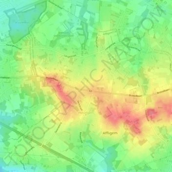
Name: Hekelgem topographic map, elevation, terrain.
Average elevation: 138 ft
Minimum elevation: 30 ft
Maximum elevation: 256 ft
Thank you for supporting this site ❤️
Make a donation
Make a donation
Gear up for your next adventure:
As an Amazon Associate, this site earns from qualifying purchases at no extra cost to you.