
Saint-Denis topographic map
Interactive map
Click on the map to display elevation.
About this map
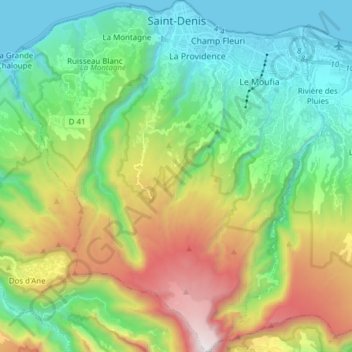
Name: Saint-Denis topographic map, elevation, terrain.
Location: Saint-Denis, Réunion, France (-21.01505 55.37563 -20.87174 55.51269)
Average elevation: 2,369 ft
Minimum elevation: 0 ft
Maximum elevation: 7,434 ft
The city is located on the north end of the island, and was a port. Saint-Denis was "originally the main port of Réunion, but an artificial harbour at Le Port, on the northwest coast, replaced it in the 1880s, because of unpredictable winds and tides at Saint-Denis." The city includes some of the island's mountains, with a peak elevation of 2,276 meters (7,467 ft) within the metro area, which begins at sea level at the coast line.[8]
Other topographic maps
Click on a map to view its topography, its elevation and its terrain.
Plateau Goyaves
France > Réunion > Saint-Louis > Plateau Goyaves
Plateau Goyaves, Saint-Louis, Saint-Pierre, Réunion, 97450, France
Average elevation: 331 ft
Gîte du Volcan
France > Réunion > Sainte-Rose
Gîte du Volcan, Sentier du Fond de la Rivière de l'Est, Sainte-Rose, Saint-Benoît, Réunion, 97439, France
Average elevation: 6,978 ft
Hell Bourg
France > Réunion > Hell Bourg
Hell-Bourg, Hell Bourg, Saint-Benoît, Réunion, 97433, France
Average elevation: 3,714 ft
Takamaka
France > Réunion > Saint-Benoît
Takamaka, Chemin Grand Fond, Saint-Benoît, Réunion, 97431, France
Average elevation: 2,792 ft
Hell Bourg
France > Réunion > Hell Bourg
Hell Bourg, Saint-Benoît, Réunion, France
Average elevation: 3,409 ft
Roche Écrite
France > Réunion > Saint-Denis
Roche Écrite, Saint-Denis, Réunion, France
Average elevation: 5,213 ft
Piton de la Fournaise
France > Réunion > Saint-Philippe
Piton de la Fournaise, Saint-Philippe, Saint-Pierre, Réunion, 97442, France
Average elevation: 7,717 ft