
Marriott-Slaterville topographic map
Click on the map to display elevation.
About this map
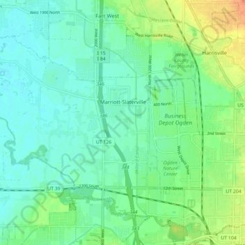
Name: Marriott-Slaterville topographic map, elevation, terrain.
Location: Marriott-Slaterville, Weber County, Utah, United States (41.23423 -112.08428 41.29020 -111.99609)
Average elevation: 4,262 ft
Minimum elevation: 4,226 ft
Maximum elevation: 4,344 ft
Weber County trails, hiking, mountain biking, running and outdoor activities
Other topographic maps
Click on a map to view its topography, its elevation and its terrain.
Ogden
United States > Utah > Weber County > Ogden
According to the United States Census Bureau, the city has an area of 26.6 square miles (69.0 km2), all land. Elevations in the city range from about 4,300 to 5,000 feet (1,300 to 1,500 m) above sea level.
Average elevation: 5,108 ft