Geolocate

Melitopol topographic map

Click on the map to display elevation.

About this map

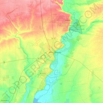
Name: Melitopol topographic map, elevation, terrain.

Location: Melitopol, Zaporizhia Oblast, 72300-72324, Ukraine (46.68875 35.20764 47.00875 35.52764)

Average elevation: 121 ft

Minimum elevation: -3 ft

Maximum elevation: 282 ft

Gear up for your next adventure:

😴Insulated Sleeping Pads - Compact and warm pads for high-elevation camping
🪶Survival Guide Book - Expert advice for emergency preparedness
🌧️Backpack Rain Cover - Keep gear dry in wet weather
📚Navigation Handbooks - Master the art of reading topographic maps and using a compass
🛠️Backpacking Tool Kit - Essential toolkit for outdoor repairs

As an Amazon Associate, this site earns from qualifying purchases at no extra cost to you.