
Make a donation
Gear up for your next adventure:
As an Amazon Associate, this site earns from qualifying purchases at no extra cost to you.
Croydon topographic map
Click on the map to display elevation.
Make a donation
Gear up for your next adventure:
As an Amazon Associate, this site earns from qualifying purchases at no extra cost to you.
About this map
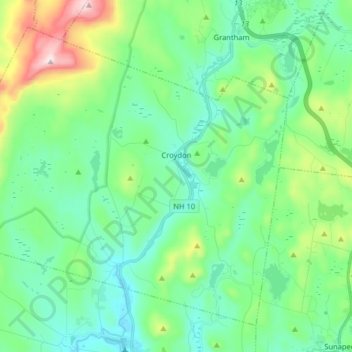
Name: Croydon topographic map, elevation, terrain.
Location: Croydon, Sullivan County, New Hampshire, United States (43.39440 -72.27186 43.49337 -72.11136)
Average elevation: 1,220 ft
Minimum elevation: 748 ft
Maximum elevation: 2,726 ft
Sullivan County trails, hiking, mountain biking, running and outdoor activities
Make a donation
Gear up for your next adventure:
As an Amazon Associate, this site earns from qualifying purchases at no extra cost to you.
Other topographic maps
Click on a map to view its topography, its elevation and its terrain.
Eastman
United States > New Hampshire > Sullivan County > Grantham > Eastman
Average elevation: 1,138 ft
Mill Hollow
United States > New Hampshire > Sullivan County > Plainfield > Mill Hollow
Average elevation: 1,027 ft
Green Mountain
United States > New Hampshire > Sullivan County > Claremont
Average elevation: 1,463 ft
Make a donation
Gear up for your next adventure:
As an Amazon Associate, this site earns from qualifying purchases at no extra cost to you.