Geolocate

Macomb topographic map

Click on the map to display elevation.

About this map

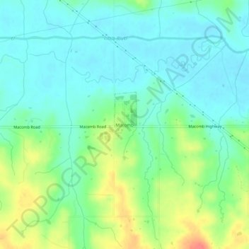
Name: Macomb topographic map, elevation, terrain.

Location: Macomb, Pottawatomie County, Oklahoma, 74852, United States (35.12547 -97.02884 35.16547 -96.98884)

Average elevation: 978 ft

Minimum elevation: 919 ft

Maximum elevation: 1,106 ft

Pottawatomie County trails, hiking, mountain biking, running and outdoor activities

Gear up for your next adventure:

🕶️Glacier Sunglasses - Side shields to protect eyes from high-altitude snow glare
📚Navigation Handbooks - Master the art of reading topographic maps and using a compass
🧣Hiking Neck Gaiter - Multi‑use neck protection for outdoor weather
🧤Hiking Gloves - Protective gloves for rugged trails
🔋Solar Power Banks - Keep your GPS and phone charged in remote wilderness areas

As an Amazon Associate, this site earns from qualifying purchases at no extra cost to you.