
Make a donation
Gear up for your next adventure:
As an Amazon Associate, this site earns from qualifying purchases at no extra cost to you.
Le Pinier topographic map
Click on the map to display elevation.
Make a donation
Gear up for your next adventure:
As an Amazon Associate, this site earns from qualifying purchases at no extra cost to you.
About this map
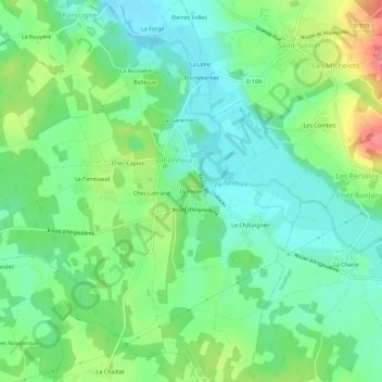
Name: Le Pinier topographic map, elevation, terrain.
Average elevation: 384 ft
Minimum elevation: 289 ft
Maximum elevation: 574 ft
Make a donation
Gear up for your next adventure:
As an Amazon Associate, this site earns from qualifying purchases at no extra cost to you.
Other topographic maps
Click on a map to view its topography, its elevation and its terrain.
Rancogne
France > Nouvelle-Aquitaine > Charente > Moulins-sur-Tardoire
Le relief de la commune est celui d'un bas plateau d'une altitude moyenne de 110 m dominant la vallée de la Tardoire sur sa rive gauche. Sur la rive droite, le sol s'élève en pente plus douce vers l'est rendant la vallée assez large. Le point culminant est à une altitude de 136 m, situé en limite sud de…
Average elevation: 344 ft