Geolocate

Pukanec topographic map

Interactive map

Click on the map to display elevation.

About this map

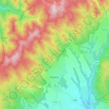
Name: Pukanec topographic map, elevation, terrain.

Location: Pukanec, District of Levice, Region of Nitra, Western Slovakia, 935 05, Slovakia (48.33491 18.67904 48.39388 18.76512)

Average elevation: 1,516 ft

Minimum elevation: 850 ft

Maximum elevation: 2,438 ft

The village lies at an altitude of 354 metres and covers an area of 26.196 km2. It has a population of 2067 people. It is located near the Štiavnica Mountains, in the Sikenica river valley. It is located around 18 km northeast of Levice.

Wikipedia (CC-BY-SA 3.0)

Other topographic maps

Click on a map to view its topography, its elevation and its terrain.

Nový Tekov

Slovakia > Region of Nitra > District of Levice

Nový Tekov, District of Levice, Region of Nitra, Western Slovakia, 935 33, Slovakia

Average elevation: 577 ft

Veľký Ďur

Slovakia > Region of Nitra > District of Levice

Veľký Ďur, District of Levice, Region of Nitra, Western Slovakia, 935 34, Slovakia

Average elevation: 630 ft