Geolocate

Osmeña topographic map

Click on the map to display elevation.

About this map

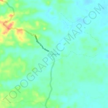
Name: Osmeña topographic map, elevation, terrain.

Location: Osmeña, La Paz, Agusan del Sur, Caraga, Philippines (8.28078 125.76522 8.32078 125.80522)

Average elevation: 102 ft

Minimum elevation: 62 ft

Maximum elevation: 203 ft

Gear up for your next adventure:

🦶Hiking Gaiters - Keep debris and water out of your boots
🪶Survival Guide Book - Expert advice for emergency preparedness
🚗GPS Dash Cams - Record your scenic drives through mountain passes and canyons
🪶Multi‑Purpose Knife - Useful blade for camp and trail
📷Action Camera - Capture your outdoor adventures in HD

As an Amazon Associate, this site earns from qualifying purchases at no extra cost to you.