
Make a donation
Gear up for your next adventure:
As an Amazon Associate, this site earns from qualifying purchases at no extra cost to you.
Brüggen topographic map
Click on the map to display elevation.
Make a donation
Gear up for your next adventure:
As an Amazon Associate, this site earns from qualifying purchases at no extra cost to you.
About this map
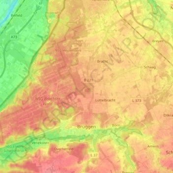
Name: Brüggen topographic map, elevation, terrain.
Location: Brüggen, Kreis Viersen, Nordrhein-Westfalen, 41379, Deutschland (51.22732 6.07265 51.30745 6.24146)
Average elevation: 161 ft
Minimum elevation: 30 ft
Maximum elevation: 243 ft
Make a donation
Gear up for your next adventure:
As an Amazon Associate, this site earns from qualifying purchases at no extra cost to you.
Other topographic maps
Click on a map to view its topography, its elevation and its terrain.
Oberkrüchten
Deutschland > Nordrhein-Westfalen > Kreis Viersen > Niederkrüchten
Average elevation: 220 ft
Make a donation
Gear up for your next adventure:
As an Amazon Associate, this site earns from qualifying purchases at no extra cost to you.