
Córdoba topographic map
Click on the map to display elevation.
Córdoba
Córdoba is located in the center of the state of Veracruz, at 18º51'30" north latitude and 96º55'51" west longitude. It lies between the hills of Matlaquiahitl and Tepixtepec, at an elevation of 817 meters (2,680 feet) above mean sea level.
About this map
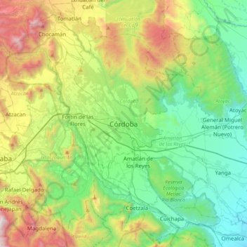
Name: Córdoba topographic map, elevation, terrain.
Location: Córdoba, Veracruz, 94500, Mexico (18.73447 -97.09529 19.05447 -96.77529)
Average elevation: 3,379 ft
Minimum elevation: 1,220 ft
Maximum elevation: 8,307 ft