
Thank you for supporting this site ❤️
Make a donation
Make a donation
Gear up for your next adventure:
As an Amazon Associate, this site earns from qualifying purchases at no extra cost to you.
Mégrine topographic map
Click on the map to display elevation.
Thank you for supporting this site ❤️
Make a donation
Make a donation
Gear up for your next adventure:
As an Amazon Associate, this site earns from qualifying purchases at no extra cost to you.
About this map
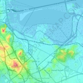
Name: Mégrine topographic map, elevation, terrain.
Location: Mégrine, مقرين العليا, معتمدية مقرين, Ben Arous, 2033, Tunisia (36.73034 10.19159 36.81034 10.27159)
Average elevation: 36 ft
Minimum elevation: -23 ft
Maximum elevation: 282 ft
Thank you for supporting this site ❤️
Make a donation
Make a donation
Gear up for your next adventure:
As an Amazon Associate, this site earns from qualifying purchases at no extra cost to you.