
Ojén topographic map
Click on the map to display elevation.
Ojén
The town is situated beside the Almadán stream above the valley of the River Real at an altitude of approximately 200 metres, hemmed in by the Sierra Blanca and the Sierra Alpujata. These may provide a clue to the Moors' determination to stay in spite of their apparent antipathy, for both ranges of mountains have long been known as rich sources of talc, nickel, iron and lead. This mineral wealth put the area in the forefront of the Spanish industrial revolution of the 19th century.
About this map
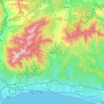
Name: Ojén topographic map, elevation, terrain.
Location: Ojén, Sierra de las Nieves, Malaga, Andalusia, 29610, Spain (36.52108 -4.92218 36.60949 -4.73540)
Average elevation: 1,325 ft
Minimum elevation: -3 ft
Maximum elevation: 4,114 ft