
Tolleric topographic map
Interactive map
Click on the map to display elevation.
About this map
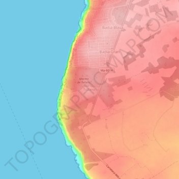
Name: Tolleric topographic map, elevation, terrain.
Location: Tolleric, Llucmajor, Migjorn, Balearische Inseln, 07609, Spanien (39.39848 2.72888 39.43848 2.76888)
Average elevation: 240 ft
Minimum elevation: 0 ft
Maximum elevation: 472 ft
Other topographic maps
Click on a map to view its topography, its elevation and its terrain.
Maioris Dècima
Spanien > Balearische Inseln > Migjorn
Maioris Dècima, Llucmajor, Migjorn, Balearische Inseln, 07609, Spanien
Average elevation: 230 ft
Cala Llombards
Spanien > Balearische Inseln > Migjorn > Santanyí
Cala Llombards, Santanyí, Migjorn, Balearische Inseln, 07690, Spanien
Average elevation: 62 ft
Colònia de Sant Jordi
Spanien > Balearische Inseln > Migjorn
Colònia de Sant Jordi, ses Salines, Migjorn, Balearische Inseln, 07638, Spanien
Average elevation: 13 ft
Cala Pi
Spanien > Balearische Inseln > Migjorn > Cala Pi
Cala Pi, Llucmajor, Migjorn, Balearische Inseln, Spanien
Average elevation: 89 ft
Son Verí
Spanien > Balearische Inseln > Migjorn
Son Verí, Llucmajor, Migjorn, Balearische Inseln, 07600, Spanien
Average elevation: 66 ft
Felanich
Spanien > Balearische Inseln > Migjorn
Felanich, Migjorn, Balearische Inseln, Spanien
Average elevation: 331 ft
Porto Petro
Spanien > Balearische Inseln > Migjorn > Santanyí
Porto Petro, Santanyí, Migjorn, Balearische Inseln, 07691, Spanien
Average elevation: 52 ft
Campos
Spanien > Balearische Inseln > Migjorn
Campos, Migjorn, Balearische Inseln, Spanien
Average elevation: 144 ft