Geolocate

Dispur topographic map

Click on the map to display elevation.

About this map

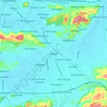
Name: Dispur topographic map, elevation, terrain.

Location: Dispur, Kamrup Metropolitan, Assam, 781005, India (26.10094 91.75103 26.18094 91.83103)

Average elevation: 256 ft

Minimum elevation: 157 ft

Maximum elevation: 896 ft

Gear up for your next adventure:

🪶Wildlife Field Guides - Learn animal tracking and species ID
🍳Camping Cook Set - Complete cookware for outdoor meals
🧭Orienteering Set - Complete compass and map reading kit
❄️Traction Cleats - Prevent slips on icy trails during winter hikes
🔌USB Car Charger - Car charger for on‑the‑go power needs

As an Amazon Associate, this site earns from qualifying purchases at no extra cost to you.