
Thank you for supporting this site ❤️
Make a donation
Make a donation
Gear up for your next adventure:
As an Amazon Associate, this site earns from qualifying purchases at no extra cost to you.
Mekoryuk topographic map
Click on the map to display elevation.
Thank you for supporting this site ❤️
Make a donation
Make a donation
Gear up for your next adventure:
As an Amazon Associate, this site earns from qualifying purchases at no extra cost to you.
About this map
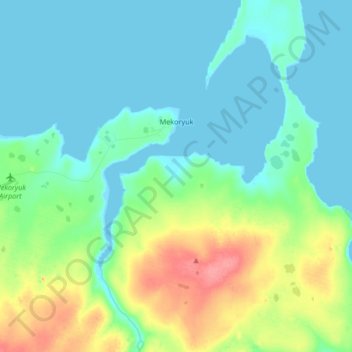
Name: Mekoryuk topographic map, elevation, terrain.
Location: Mekoryuk, Unorganized Borough, Alaska, United States (60.35886 -166.35130 60.39149 -166.18416)
Average elevation: 59 ft
Minimum elevation: -7 ft
Maximum elevation: 226 ft
Unorganized Borough trails, hiking, mountain biking, running and outdoor activities
Thank you for supporting this site ❤️
Make a donation
Make a donation
Gear up for your next adventure:
As an Amazon Associate, this site earns from qualifying purchases at no extra cost to you.