Geolocate

Basuit topographic map

Click on the map to display elevation.

About this map

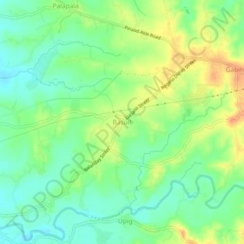
Name: Basuit topographic map, elevation, terrain.

Location: Basuit, San Ildefonso, Bulacan, Central Luzon, Philippines (15.02140 120.97129 15.06140 121.01129)

Average elevation: 128 ft

Minimum elevation: 69 ft

Maximum elevation: 207 ft

Other topographic maps

Click on a map to view its topography, its elevation and its terrain.

Akle

Philippines > Bulacan > San Ildefonso

Average elevation: 420 ft

Palapala

Philippines > Bulacan > San Ildefonso

Average elevation: 112 ft

Gear up for your next adventure:

🧦Merino Wool Socks - Moisture-wicking, blister-preventing socks for long treks
🖼️Topo Map Wall Art - Decorative topographic prints of famous peaks and regions
🗻Climbing Gear Basics - Essential gear for beginner climbers
🛠️Outdoor Gear Repair Kit - Essential tools to fix gear on the trail
🔊Portable Camp Speaker - Music and alerts at camp

As an Amazon Associate, this site earns from qualifying purchases at no extra cost to you.