
Dunstable topographic map
Click on the map to display elevation.
About this map
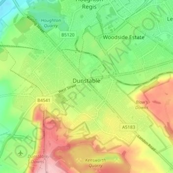
Name: Dunstable topographic map, elevation, terrain.
Location: Dunstable, Central Bedfordshire, England, United Kingdom (51.86958 -0.55063 51.89972 -0.48397)
Average elevation: 518 ft
Minimum elevation: 305 ft
Maximum elevation: 801 ft
Other topographic maps
Click on a map to view its topography, its elevation and its terrain.
Little Billington
United Kingdom > England > Central Bedfordshire > Great Billington > Little Billington
Average elevation: 302 ft
Redlodge Plantation
United Kingdom > England > Central Bedfordshire > Woburn
Average elevation: 400 ft