
Thank you for supporting this site ❤️
Make a donation
Make a donation
Gear up for your next adventure:
As an Amazon Associate, this site earns from qualifying purchases at no extra cost to you.
Soloy topographic map
Click on the map to display elevation.
Thank you for supporting this site ❤️
Make a donation
Make a donation
Gear up for your next adventure:
As an Amazon Associate, this site earns from qualifying purchases at no extra cost to you.
About this map
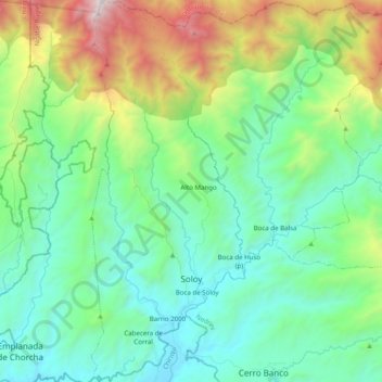
Name: Soloy topographic map, elevation, terrain.
Location: Soloy, Distrito Besikó, Comarca Ngäbe Buglé, Panama (8.45020 -82.12702 8.64566 -82.04766)
Average elevation: 2,106 ft
Minimum elevation: 299 ft
Maximum elevation: 7,333 ft
Thank you for supporting this site ❤️
Make a donation
Make a donation
Gear up for your next adventure:
As an Amazon Associate, this site earns from qualifying purchases at no extra cost to you.