Geolocate

Barnesville topographic map

Click on the map to display elevation.

About this map

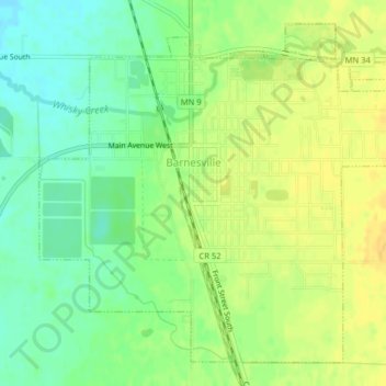
Name: Barnesville topographic map, elevation, terrain.

Location: Barnesville, Clay County, Minnesota, 56514, United States (46.63790 -96.43583 46.66208 -96.39578)

Average elevation: 1,020 ft

Minimum elevation: 974 ft

Maximum elevation: 1,056 ft

Clay County trails, hiking, mountain biking, running and outdoor activities

Other topographic maps

Click on a map to view its topography, its elevation and its terrain.

Baker

United States > Minnesota > Clay County

Average elevation: 938 ft

Hitterdahl WMA

United States > Minnesota > Clay County

Average elevation: 1,243 ft

Moorhead

United States > Minnesota > Clay County > Moorhead > Moorhead

Average elevation: 909 ft

Kragnes

United States > Minnesota > Clay County

Average elevation: 896 ft

Gear up for your next adventure:

⛑️Personal Locator Beacon - Safety beacon for emergencies
❄️Traction Cleats - Prevent slips on icy trails during winter hikes
🔦Compact Flashlight - Reliable flashlight for emergencies
🥾Hiking Shoes - Durable and comfortable shoes for trail hiking
🌡️Handheld Weather Meters - Measure wind, temp, and pressure for safe mountain travel

As an Amazon Associate, this site earns from qualifying purchases at no extra cost to you.