
Make a donation
Gear up for your next adventure:
As an Amazon Associate, this site earns from qualifying purchases at no extra cost to you.
Lübarser Höhe topographic map
Click on the map to display elevation.
Make a donation
Gear up for your next adventure:
As an Amazon Associate, this site earns from qualifying purchases at no extra cost to you.
About this map
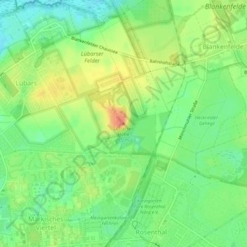
Name: Lübarser Höhe topographic map, elevation, terrain.
Location: Lübarser Höhe, Berlin, 13158, Deutschland (52.61014 13.37048 52.61024 13.37058)
Average elevation: 167 ft
Minimum elevation: 98 ft
Maximum elevation: 249 ft
Make a donation
Gear up for your next adventure:
As an Amazon Associate, this site earns from qualifying purchases at no extra cost to you.
Other topographic maps
Click on a map to view its topography, its elevation and its terrain.
Lützowplatz
Deutschland > Berlin > Berlin
Die Schillstraße wurde auf Höhe des Platzes am 8. September 1929 ebenfalls in Lützowplatz umbenannt.
Average elevation: 131 ft
Make a donation
Gear up for your next adventure:
As an Amazon Associate, this site earns from qualifying purchases at no extra cost to you.