Make a donation
Gear up for your next adventure:
As an Amazon Associate, this site earns from qualifying purchases at no extra cost to you.
Berkhamsted topographic map
Click on the map to display elevation.
Make a donation
Gear up for your next adventure:
As an Amazon Associate, this site earns from qualifying purchases at no extra cost to you.
Berkhamsted
The layout of Berkhamsted's centre is typical of a medieval market settlement: the linear High Street (aligned on the Akeman Street) forms the spine of the town (roughly aligned east–west), from which extend medieval burgage plots (to the north and south). The surviving burgage plot layout is the result of a comprehensive plan carried out at the beginning of the 13th century, most probably instigated by Geoffrey fitz Peter. The town centre slowly developed over the years and contains a wide variety of properties that date from the 13th century onwards. The modern town began to develop after the construction of the Grand Junction Canal in 1798. The canal intersects the river at numerous points, taking most of its water supply and helping to drain the valley. The locality became further urbanised when the London to Birmingham railway was built in 1836–37. The townscape was shaped by the Bulbourne valley, which rises 300 feet (91 metres) on either side at its narrowest point; the residential area is elongated and follows the valley's topography. The southwest side of the valley is more developed, with side streets running up the steep hillside; on the northeast side, the ground gently slopes down to the castle, railway, canal and small river, was less available for development. Today, Berkhamsted is an affluent, "pleasant town tucked in a wooded fold in the Chiltern Hills"; with a large section of the settlement protected as a conservation area.
Make a donation
Gear up for your next adventure:
As an Amazon Associate, this site earns from qualifying purchases at no extra cost to you.
About this map
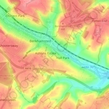
Name: Berkhamsted topographic map, elevation, terrain.
Location: Berkhamsted, Dacorum, Hertfordshire, England, United Kingdom (51.73573 -0.59360 51.77455 -0.52201)
Average elevation: 466 ft
Minimum elevation: 295 ft
Maximum elevation: 597 ft
Make a donation
Gear up for your next adventure:
As an Amazon Associate, this site earns from qualifying purchases at no extra cost to you.
Other topographic maps
Click on a map to view its topography, its elevation and its terrain.
Bovingdon Green
United Kingdom > England > Hertfordshire > Dacorum > Bovingdon
Average elevation: 495 ft
Nettleden
United Kingdom > England > Hertfordshire > Dacorum > Great Gaddesden
Average elevation: 489 ft
Make a donation
Gear up for your next adventure:
As an Amazon Associate, this site earns from qualifying purchases at no extra cost to you.
Westbrook Mere
United Kingdom > England > Hertfordshire > Dacorum > Bourne End
Average elevation: 410 ft
Trowley Bottom
United Kingdom > England > Hertfordshire > Dacorum > Flamstead
Average elevation: 456 ft
Make a donation
Gear up for your next adventure:
As an Amazon Associate, this site earns from qualifying purchases at no extra cost to you.
Dixon's Gap Bridge
United Kingdom > England > Hertfordshire > Dacorum > Wilstone > Gubblecote
Average elevation: 331 ft
Make a donation
Gear up for your next adventure:
As an Amazon Associate, this site earns from qualifying purchases at no extra cost to you.
Make a donation
Gear up for your next adventure:
As an Amazon Associate, this site earns from qualifying purchases at no extra cost to you.
Little Heath
United Kingdom > England > Hertfordshire > Dacorum > Potten End
Average elevation: 453 ft
Make a donation
Gear up for your next adventure:
As an Amazon Associate, this site earns from qualifying purchases at no extra cost to you.
Saint Margarets Copse
United Kingdom > England > Hertfordshire > Dacorum > Great Gaddesden
Average elevation: 472 ft
Hammerfield
United Kingdom > England > Hertfordshire > Dacorum > Hemel Hempstead
Average elevation: 400 ft
Tringford Reservoir
United Kingdom > England > Hertfordshire > Dacorum > Tring > Wilstone
Average elevation: 390 ft
Make a donation
Gear up for your next adventure:
As an Amazon Associate, this site earns from qualifying purchases at no extra cost to you.
Long Marston
United Kingdom > England > Hertfordshire > Dacorum > Long Marston
Average elevation: 302 ft
Frithsden Beeches
United Kingdom > England > Hertfordshire > Dacorum > Potten End
Average elevation: 525 ft
Make a donation
Gear up for your next adventure:
As an Amazon Associate, this site earns from qualifying purchases at no extra cost to you.
