Geolocate

Lake Timpson topographic map

Click on the map to display elevation.

About this map

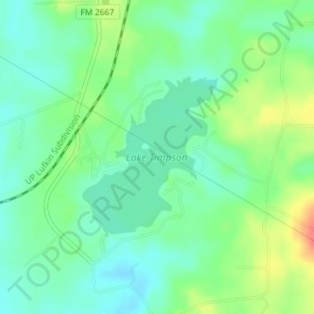
Name: Lake Timpson topographic map, elevation, terrain.

Location: Lake Timpson, Shelby County, Texas, United States (31.84425 -94.43220 31.85803 -94.41843)

Average elevation: 335 ft

Minimum elevation: 272 ft

Maximum elevation: 456 ft

Shelby County trails, hiking, mountain biking, running and outdoor activities

Other topographic maps

Click on a map to view its topography, its elevation and its terrain.

Mount Herman

United States > Texas > Shelby County

Average elevation: 407 ft

Gear up for your next adventure:

🎒Waterproof Dry Bags - Keep your electronics and maps dry inside your pack
🧭Compass with Lanyard - Easy‑carry compass for navigation
🧦Merino Wool Socks - Moisture-wicking, blister-preventing socks for long treks
🔊Portable Camp Speaker - Music and alerts at camp
🥾Women's Hiking Boots - Top-rated trail boots with ankle support and superior grip

As an Amazon Associate, this site earns from qualifying purchases at no extra cost to you.