Geolocate

Cumbicus topographic map

Click on the map to display elevation.

👉 Easily get elevation data in JSON, GeoTIFF and KML formats using Elevation API
Thank you for supporting this site ❤️
Make a donation

About this map

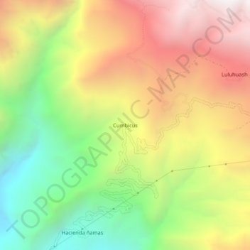
Name: Cumbicus topographic map, elevation, terrain.

Location: Cumbicus, Magdalena, Cajamarca, Perú (-7.23386 -78.65263 -7.19386 -78.61263)

Average elevation: 8,471 ft

Minimum elevation: 5,551 ft

Maximum elevation: 11,522 ft

Gear up for your next adventure:

🎒Outdoor Daypacks - Lightweight backpacks designed for carrying maps and essential gear
📡Handheld GPS Device - Reliable handheld GPS for outdoor navigation
🧼Biodegradable Camping Soap - Eco‑friendly soap for outdoor hygiene
📖Nature Tracking Books - Learn to track wildlife and terrain
🗺️NatGeo Topo Maps - High-quality waterproof printed topographic maps of US Parks

As an Amazon Associate, this site earns from qualifying purchases at no extra cost to you.