
Make a donation
Gear up for your next adventure:
As an Amazon Associate, this site earns from qualifying purchases at no extra cost to you.
Porto Feliz topographic map
Click on the map to display elevation.
Make a donation
Gear up for your next adventure:
As an Amazon Associate, this site earns from qualifying purchases at no extra cost to you.
Porto Feliz
Porto Feliz (Portuguese: Happy Haven) is a municipality in the Brazilian state of São Paulo. It is part of the Metropolitan Region of Sorocaba. The population is 53,402 (2020 est.) in an area of 556.69 km². The elevation is 523 m. The largest factory in the city called a Porto Feliz S/A is responsible for the demand for corrugated cardboard packaging of the entire state and all Brazil. The mother of Queen Silvia of Sweden, Alice Soares de Toledo, was born in this city.
Make a donation
Gear up for your next adventure:
As an Amazon Associate, this site earns from qualifying purchases at no extra cost to you.
About this map
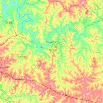
Name: Porto Feliz topographic map, elevation, terrain.
Average elevation: 1,834 ft
Minimum elevation: 1,552 ft
Maximum elevation: 2,205 ft
Make a donation
Gear up for your next adventure:
As an Amazon Associate, this site earns from qualifying purchases at no extra cost to you.