
Huzur Tahsil topographic map
Interactive map
Click on the map to display elevation.
About this map
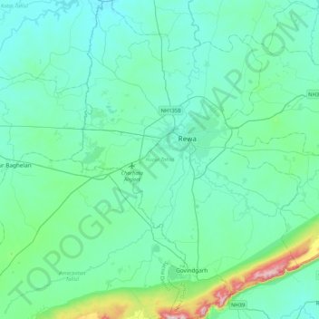
Name: Huzur Tahsil topographic map, elevation, terrain.
Location: Huzur Tahsil, Rewa, Madhya Pradesh, India (24.31992 81.14091 24.70077 81.44264)
Average elevation: 1,066 ft
Minimum elevation: 886 ft
Maximum elevation: 2,231 ft
Other topographic maps
Click on a map to view its topography, its elevation and its terrain.
Bhopal
India > Madhya Pradesh > Huzur Tahsil
Bhopal, Huzur Tahsil, Bhopal District, Madhya Pradesh, 462001, India
Average elevation: 1,634 ft
Sarangpani Lake
India > Madhya Pradesh > Huzur Tahsil > Bhopal
Sarangpani Lake, Piplani, BHEL Township, Bhopal, Huzur Tahsil, Bhopal District, Madhya Pradesh, 462001, India
Average elevation: 1,608 ft
Kuthar
India > Madhya Pradesh > Huzur Tahsil
Kuthar, Huzur Tahsil, Bhopal District, Madhya Pradesh, India
Average elevation: 1,667 ft
Islamnagar
India > Madhya Pradesh > Huzur Tahsil
Islamnagar, Huzur Tahsil, Bhopal District, Madhya Pradesh, 462038, India
Average elevation: 1,591 ft
Van Vihar National Park
India > Madhya Pradesh > Huzur Tahsil > Bhopal
Van Vihar National Park, Bhopal, Huzur Tahsil, Bhopal, Madhya Pradesh, 462001, India
Average elevation: 1,742 ft