Geolocate

Passail topographic map

Click on the map to display elevation.

About this map

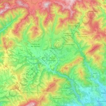
Name: Passail topographic map, elevation, terrain.

Location: Passail, Bezirk Weiz, Styria, 8162, Austria (47.19847 15.43653 47.35148 15.58373)

Average elevation: 2,871 ft

Minimum elevation: 1,483 ft

Maximum elevation: 5,000 ft

Other topographic maps

Click on a map to view its topography, its elevation and its terrain.

Teichalm

Austria > Styria > Bezirk Weiz > Fladnitz an der Teichalm

Average elevation: 3,993 ft

Gmoa

Austria > Styria > Bezirk Weiz > Fischbach

Average elevation: 3,501 ft

Pichl an der Raab

Austria > Styria > Bezirk Weiz

Average elevation: 1,453 ft

Plenzengreith

Austria > Styria > Bezirk Weiz

Average elevation: 3,104 ft

Gear up for your next adventure:

🛶Inflatable Kayak - Portable kayak for rivers, lakes, and expeditions
🪑Ultralight Camp Chairs - Portable seating for resting after a long day of mapping
🧭Outdoor Navigation Book - Learn advanced navigation skills
📶Satellite Messenger - Communication device off‑grid
🌄Hiking Binoculars - Compact binoculars for scenic views and trail spotting

As an Amazon Associate, this site earns from qualifying purchases at no extra cost to you.