Geolocate

Mampad topographic map

Click on the map to display elevation.

About this map

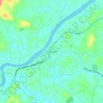
Name: Mampad topographic map, elevation, terrain.

Location: Mampad, Nilambur, Malappuram, Kerala, 676542, India (11.22466 76.15936 11.26466 76.19936)

Average elevation: 98 ft

Minimum elevation: 10 ft

Maximum elevation: 427 ft

Other topographic maps

Click on a map to view its topography, its elevation and its terrain.

Munderi

India > Kerala > Nilambur

Average elevation: 1,506 ft

Muthukadu

India > Kerala > Nilambur > Nilambur

Average elevation: 118 ft

Nilamboor

India > Kerala > Nilambur

Average elevation: 1,808 ft

Gear up for your next adventure:

🎒Gear Packing Cubes - Organize your backpack efficiently
🪶Paracord Bracelet - Survival bracelet with built‑in tools
🔪Outdoor Multitools - Essential survival tools for gear repair and field use
🔥Plasma Lighters - Windproof lighters that work in any weather condition
💧Water Filtration Bottles - Safely drink from streams and lakes while exploring

As an Amazon Associate, this site earns from qualifying purchases at no extra cost to you.