
Makhachkala topographic map
Interactive map
Click on the map to display elevation.
About this map
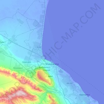
Name: Makhachkala topographic map, elevation, terrain.
Average elevation: 187 ft
Minimum elevation: -98 ft
Maximum elevation: 2,900 ft
Other topographic maps
Click on a map to view its topography, its elevation and its terrain.
Chechen Island
Russia > Dagestan > Makhachkala Urban Okrug
Chechen Island, Makhachkala Urban Okrug, Dagestan, North Caucasian Federal District, Russia
Average elevation: -89 ft