
Laloux topographic map
Interactive map
Click on the map to display elevation.
About this map
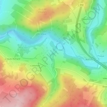
Name: Laloux topographic map, elevation, terrain.
Location: Laloux, Stavelot, Verviers, Liège, Wallonie, 4970, Belgique (50.37831 5.96382 50.39831 5.98382)
Average elevation: 1,247 ft
Minimum elevation: 919 ft
Maximum elevation: 1,696 ft
Other topographic maps
Click on a map to view its topography, its elevation and its terrain.