
Make a donation
Gear up for your next adventure:
As an Amazon Associate, this site earns from qualifying purchases at no extra cost to you.
La Carlota topographic map
Click on the map to display elevation.
Make a donation
Gear up for your next adventure:
As an Amazon Associate, this site earns from qualifying purchases at no extra cost to you.
About this map
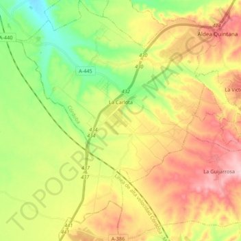
Name: La Carlota topographic map, elevation, terrain.
Location: La Carlota, Córdoba, Andalusia, Spain (37.59974 -5.01603 37.72972 -4.86323)
Average elevation: 699 ft
Minimum elevation: 384 ft
Maximum elevation: 1,066 ft
Make a donation
Gear up for your next adventure:
As an Amazon Associate, this site earns from qualifying purchases at no extra cost to you.
Other topographic maps
Click on a map to view its topography, its elevation and its terrain.
Piedra del Águila
Spain > Andalusia > Comarca de Huéscar > Puebla de Don Fadrique
Average elevation: 4,249 ft
Cerro de Fabián
Spain > Andalusia > Sierra de Cádiz > Villaluenga del Rosario
Average elevation: 2,415 ft
Make a donation
Gear up for your next adventure:
As an Amazon Associate, this site earns from qualifying purchases at no extra cost to you.