
Make a donation
Gear up for your next adventure:
As an Amazon Associate, this site earns from qualifying purchases at no extra cost to you.
Miraflores topographic map
Click on the map to display elevation.
Make a donation
Gear up for your next adventure:
As an Amazon Associate, this site earns from qualifying purchases at no extra cost to you.
About this map
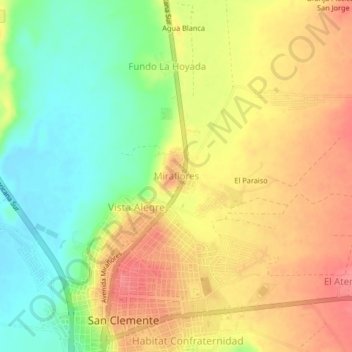
Name: Miraflores topographic map, elevation, terrain.
Location: Miraflores, San Clemente, Pisco, Ica, 11620, Perú (-13.68441 -76.17126 -13.64441 -76.13126)
Average elevation: 236 ft
Minimum elevation: 115 ft
Maximum elevation: 344 ft
Make a donation
Gear up for your next adventure:
As an Amazon Associate, this site earns from qualifying purchases at no extra cost to you.
Other topographic maps
Click on a map to view its topography, its elevation and its terrain.
San Clemente
Perú > Ica > San Clemente
El pueblo de San Clemente fue creado como distrito mediante decreto ley N° 24161 un 8 de junio de 1985. Está asentado a la ribera derecha del río Pisco, sobre un terreno de topografía ondulada, de planicies y cerros donde predominan los cascotes de salitre y tiza. Por el costado del pueblo discurre el…
Average elevation: 213 ft