
稳坪镇 topographic map
Interactive map
Click on the map to display elevation.
About this map
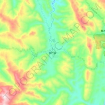
Name: 稳坪镇 topographic map, elevation, terrain.
Location: 稳坪镇, 德江县, 贵州省, 中国 (28.27450 108.17600 28.35450 108.25600)
Average elevation: 2,136 ft
Minimum elevation: 1,260 ft
Maximum elevation: 3,537 ft
Other topographic maps
Click on a map to view its topography, its elevation and its terrain.