
Make a donation
Gear up for your next adventure:
As an Amazon Associate, this site earns from qualifying purchases at no extra cost to you.
Puruliya topographic map
Click on the map to display elevation.
Make a donation
Gear up for your next adventure:
As an Amazon Associate, this site earns from qualifying purchases at no extra cost to you.
About this map
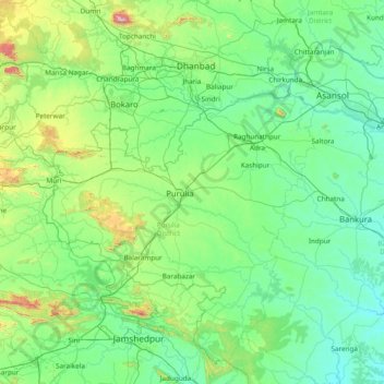
Name: Puruliya topographic map, elevation, terrain.
Location: Puruliya, Purulia District, West Bengal, 723101, India (22.63333 85.71667 24.03333 87.11667)
Average elevation: 699 ft
Minimum elevation: 164 ft
Maximum elevation: 4,331 ft
Make a donation
Gear up for your next adventure:
As an Amazon Associate, this site earns from qualifying purchases at no extra cost to you.
Other topographic maps
Click on a map to view its topography, its elevation and its terrain.
Purulia
Several rivers flow across Purulia district. Among these Kangsabati, Kumari, Silabati (silai), Dwarakeswar, Subarnarekha and Damodar are the important ones. Although several rivers flows across the district, 50% of the water run off due to the undulated topography. There are also several Small dams like…
Average elevation: 738 ft
Make a donation
Gear up for your next adventure:
As an Amazon Associate, this site earns from qualifying purchases at no extra cost to you.
Purba Medinipur District
Purba Medinipur district is part of the lower Indo-Gangetic Plain and Eastern coastal plains. Topographically, the district can be divided into two parts – (a) almost entirely flat plains on the west, east and north, (b) the coastal plains on the south. The vast expanse of land is formed of alluvium and is…
Average elevation: 20 ft
Bankura - II
Bankura II CD block is located in the central part of the district. It belongs to the Bankura-Bishnupur Rarh Plains. The elevation rises gradually in the undulating surface area but in the hilly tract it rises abruptly.
Average elevation: 331 ft
Make a donation
Gear up for your next adventure:
As an Amazon Associate, this site earns from qualifying purchases at no extra cost to you.
Mandirbazar
Mandirbazar CD block is located at 22°09′48″N 88°19′33″E / 22.1633°N 88.3258°E / 22.1633; 88.3258. It has an average elevation of 7 metres (23 ft).
Average elevation: 13 ft
Bardhaman
India > West Bengal > Burdwan - I
The region has an average elevation of 40 metres (131 ft). The city is situated 1100 km from New Delhi and a little less than 100 km north-west of Kolkata on the Grand Trunk Road (National Highway 19) and Eastern Railway. The chief rivers are the Damodar and the Banka.
Average elevation: 102 ft
Make a donation
Gear up for your next adventure:
As an Amazon Associate, this site earns from qualifying purchases at no extra cost to you.
Make a donation
Gear up for your next adventure:
As an Amazon Associate, this site earns from qualifying purchases at no extra cost to you.
Make a donation
Gear up for your next adventure:
As an Amazon Associate, this site earns from qualifying purchases at no extra cost to you.
Cooch Behar
Cooch Behar is a flat region with a slight southeastern slope along which the main rivers of the district flow. Most of the highland areas are in the Sitalkuchi region, and most of the low-lying lands lie in Dinhata region. The elevation of the town is 48 meters above mean sea level. The Torsa river flows by…
Average elevation: 135 ft
Make a donation
Gear up for your next adventure:
As an Amazon Associate, this site earns from qualifying purchases at no extra cost to you.