
Bedford topographic map
Interactive map
Click on the map to display elevation.
About this map
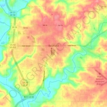
Name: Bedford topographic map, elevation, terrain.
Location: Bedford, Lawrence County, Indiana, 47421, United States (38.82550 -86.52635 38.88650 -86.43802)
Average elevation: 627 ft
Minimum elevation: 472 ft
Maximum elevation: 755 ft
Other topographic maps
Click on a map to view its topography, its elevation and its terrain.
Otis Park
United States > Indiana > Lawrence County > Bedford
Otis Park, Bedford, Lawrence County, Indiana, United States
Average elevation: 610 ft
Rabbitville
United States > Indiana > Lawrence County
Rabbitville, Lawrence County, Indiana, 47446, United States
Average elevation: 643 ft
Crawford
United States > Indiana > Lawrence County > Crawford
Crawford, Lawrence County, Indiana, United States
Average elevation: 650 ft
Springville
United States > Indiana > Lawrence County > Springville
Springville, Lawrence County, Indiana, United States
Average elevation: 719 ft
Mitchell
United States > Indiana > Lawrence County
Mitchell, Lawrence County, Indiana, 47446, United States
Average elevation: 686 ft