
Make a donation
Gear up for your next adventure:
As an Amazon Associate, this site earns from qualifying purchases at no extra cost to you.
Mathioya topographic map
Click on the map to display elevation.
Make a donation
Gear up for your next adventure:
As an Amazon Associate, this site earns from qualifying purchases at no extra cost to you.
About this map
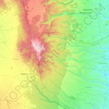
Name: Mathioya topographic map, elevation, terrain.
Location: Mathioya, Murang'a County, Central Kenya, Kenya (-0.73731 36.70649 -0.56733 37.12397)
Average elevation: 7,835 ft
Minimum elevation: 5,279 ft
Maximum elevation: 12,661 ft
Make a donation
Gear up for your next adventure:
As an Amazon Associate, this site earns from qualifying purchases at no extra cost to you.
Other topographic maps
Click on a map to view its topography, its elevation and its terrain.
Murang'a
Kenya > Murang'a County > Kiharu
The town is low, a bit hilly, small but picturesque with an altitude of 4120 ft (1255 metres) above sea level. As a result of the varying altitudes, Murang'a can get quite cold from May to mid-August, and can experience hail. To the west of the town can be seen the rolling Kikuyu farmlands that extend as far…
Average elevation: 4,219 ft
Make a donation
Gear up for your next adventure:
As an Amazon Associate, this site earns from qualifying purchases at no extra cost to you.
Make a donation
Gear up for your next adventure:
As an Amazon Associate, this site earns from qualifying purchases at no extra cost to you.