
Make a donation
Gear up for your next adventure:
As an Amazon Associate, this site earns from qualifying purchases at no extra cost to you.
Šiauliai topographic map
Click on the map to display elevation.
Make a donation
Gear up for your next adventure:
As an Amazon Associate, this site earns from qualifying purchases at no extra cost to you.
Šiauliai
Altitude: Rėkyvos the lake water level – 129.8 m (425.85 ft) above sea level, Talsos lake level – 103.0 m (337.93 ft) in the city center – 128.4 m (421.26 ft), Salduvės Hill – 149.7 m (491.14 ft) above sea level.
Make a donation
Gear up for your next adventure:
As an Amazon Associate, this site earns from qualifying purchases at no extra cost to you.
About this map
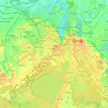
Name: Šiauliai topographic map, elevation, terrain.
Average elevation: 407 ft
Minimum elevation: 325 ft
Maximum elevation: 509 ft
Make a donation
Gear up for your next adventure:
As an Amazon Associate, this site earns from qualifying purchases at no extra cost to you.
Other topographic maps
Click on a map to view its topography, its elevation and its terrain.
Sablauskiai
Lithuania > Siauliai County > Naujosios Akmenės kaimiškoji seniūnija
Average elevation: 249 ft
Make a donation
Gear up for your next adventure:
As an Amazon Associate, this site earns from qualifying purchases at no extra cost to you.
Make a donation
Gear up for your next adventure:
As an Amazon Associate, this site earns from qualifying purchases at no extra cost to you.