Geolocate

Findlay Creek topographic map

Click on the map to display elevation.

About this map

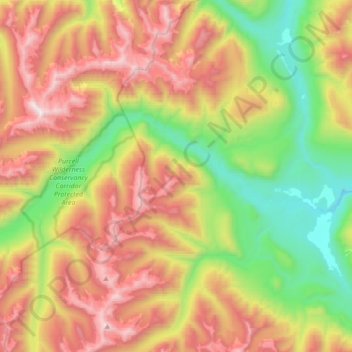
Name: Findlay Creek topographic map, elevation, terrain.

Location: Findlay Creek, Area F (Columbia Lake/Windermere Lake), Regional District of East Kootenay, British Columbia, Canada (50.10318 -116.32710 50.18103 -115.97760)

Average elevation: 6,109 ft

Minimum elevation: 3,376 ft

Maximum elevation: 9,692 ft

Other topographic maps

Click on a map to view its topography, its elevation and its terrain.

Gear up for your next adventure:

🔌USB Car Charger - Car charger for on‑the‑go power needs
🔭Telescopic Hiking Pole - Adjustable pole for hiking stability
⛑️Personal Locator Beacon - Safety beacon for emergencies
🛰️Handheld GPS Units - Professional satellite navigators for precise backcountry mapping
🥾Men's Hiking Boots - Durable, waterproof footwear for rugged terrain and steep inclines

As an Amazon Associate, this site earns from qualifying purchases at no extra cost to you.