Geolocate

Pinetown topographic map

Click on the map to display elevation.

About this map

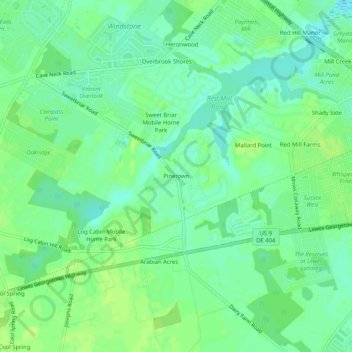
Name: Pinetown topographic map, elevation, terrain.

Location: Pinetown, Sussex County, Delaware, United States (38.72539 -75.24380 38.76539 -75.20380)

Average elevation: 26 ft

Minimum elevation: 0 ft

Maximum elevation: 46 ft

Sussex County trails, hiking, mountain biking, running and outdoor activities

Other topographic maps

Click on a map to view its topography, its elevation and its terrain.

Fenwick Island

United States > Delaware > Sussex County

Average elevation: 0 ft

Henlopen Acres

United States > Delaware > Sussex County

Average elevation: 23 ft

Bethel

United States > Delaware > Sussex County

Average elevation: 26 ft

Dagsboro

United States > Delaware > Sussex County

Average elevation: 30 ft

Blades

United States > Delaware > Sussex County

Average elevation: 23 ft

Bridgeville

United States > Delaware > Sussex County

Average elevation: 43 ft

Millville

United States > Delaware > Sussex County

Average elevation: 16 ft

Frankford

United States > Delaware > Sussex County

Average elevation: 33 ft

Dewey Beach

United States > Delaware > Sussex County

Average elevation: 7 ft

Laurel

United States > Delaware > Sussex County

Average elevation: 36 ft

Gear up for your next adventure:

🪶Survival Guide Book - Expert advice for emergency preparedness
💧Water Filtration Bottles - Safely drink from streams and lakes while exploring
🦟Ultrasonic Repellers - Create a bug-free zone at your camp or rest stop
🪶Compact Camp Shovel - Folding shovel for campsite tasks
🪓Survival Multi‑Tool - Versatile tool for camp and trail tasks

As an Amazon Associate, this site earns from qualifying purchases at no extra cost to you.