Geolocate

Vilnius County topographic map

Click on the map to display elevation.

About this map

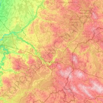
Name: Vilnius County topographic map, elevation, terrain.

Location: Vilnius County, Lithuania (54.12765 24.38667 55.51772 26.75936)

Average elevation: 479 ft

Minimum elevation: 98 ft

Maximum elevation: 1,040 ft

Other topographic maps

Click on a map to view its topography, its elevation and its terrain.

Sietynai

Lithuania > Vilnius County > Veprių seniūnija

Average elevation: 246 ft

Diržai

Lithuania > Alytus County > Leipalingio seniūnija

Average elevation: 335 ft

Mizarai

Lithuania > Alytus County > Leipalingio seniūnija

Average elevation: 344 ft

Samantonys

Lithuania > Vilnius County > Veprių seniūnija

Average elevation: 236 ft

Aukštojas

Lithuania > Vilnius County > Medininkai Eldership > Juozapinė

Aukštojas Hill is the highest point in all of Lithuania; it is located in the Medininkai Highlands, Migūnai forestry, approximately 24 kilometres (15 mi) southeast of the capital city of Vilnius. Its elevation was measured in 2004 at 293.84 metres (964.0 feet) by specialists at the Institute of Geodesy at…

Average elevation: 866 ft

Sabinė

Lithuania > Marijampole County > Sabinė

Average elevation: 213 ft

Vilnius

Lithuania > Vilnius County > Vilnius

Average elevation: 531 ft

Kaunas

Lithuania > Kaunas County > Kaunas

Average elevation: 226 ft

Klaipėda

Lithuania > Klaipeda County > Klaipėda

Average elevation: 39 ft

Maderai

Lithuania > Utena County > Antalieptė eldership

Average elevation: 495 ft

Gear up for your next adventure:

🧣Merino Neck Gaiters - Multi-functional headwear for wind and sun protection
🕶️Glacier Sunglasses - Side shields to protect eyes from high-altitude snow glare
🔋Rechargeable Batteries - Power up your outdoor devices
🪑Portable Camp Table - Compact table for campsite meals
🌎3D Topographic Globes - Raised relief globes for a tactile understanding of geography

As an Amazon Associate, this site earns from qualifying purchases at no extra cost to you.