
Bountiful topographic map
Click on the map to display elevation.
About this map
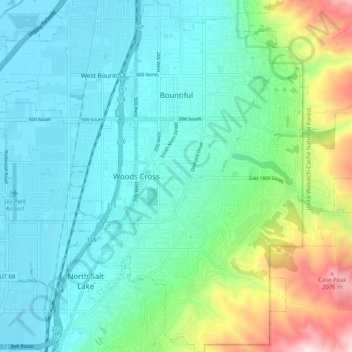
Name: Bountiful topographic map, elevation, terrain.
Location: Bountiful, Davis County, Utah, 84010, United States (40.83291 -111.90212 40.91028 -111.81538)
Average elevation: 4,846 ft
Minimum elevation: 4,199 ft
Maximum elevation: 7,087 ft
Davis County trails, hiking, mountain biking, running and outdoor activities
Other topographic maps
Click on a map to view its topography, its elevation and its terrain.
Antelope Island
United States > Utah > Davis County
The island is accessible via a 7-mile causeway from Syracuse in Davis County. Access from Interstate 15 is via exit 332, then west along Antelope Drive (SR-108). The island's shore (all but west side of the island) is mostly flat with beaches and plains to the base of the mountains on the island. These steep…
Average elevation: 4,285 ft
Mount Lebannon Acres
United States > Utah > Davis County > Centerville > Rosedale
Average elevation: 4,803 ft