
Make a donation
Gear up for your next adventure:
As an Amazon Associate, this site earns from qualifying purchases at no extra cost to you.
Sitakunda Upazila topographic map
Click on the map to display elevation.
Make a donation
Gear up for your next adventure:
As an Amazon Associate, this site earns from qualifying purchases at no extra cost to you.
Sitakunda Upazila
Sitakunda Upazila occupies an area of 483.97 square kilometres (186.86 sq mi), which includes 61.61 square kilometres (23.79 sq mi) of forest. It is bordered by Mirsharai to the north, Pahartali to the south, Fatickchhari, Hathazari and Panchlaish to the east, and the Sandwip Channel in the Bay of Bengal to the west. The Sitakunda range is a 32-kilometre (20 mi) long ridge in the center of the upazila, which reaches an altitude of 352 metres (1,155 ft) above sea level at Chandranath or Sitakunda peak, the highest peak in Chittagong District. Part of Sitakunda is covered by the low hill ranges, while the rest is in the Bengal flood plain. To the north, Rajbari Tila at 274 metres (899 ft) and Sajidhala at 244 metres (801 ft) are the highest peaks in this range, which drops abruptly to a height of less than 92 metres (302 ft) in the vicinity of Chittagong City to the south. About 5 kilometres (3 mi) north of Sitakunda Town is the Labanakhya saltwater hot spring, which has been proposed as a source of geothermal energy. There are two waterfalls in the hills: Sahasradhara (thousand streams) and Suptadhara (hidden stream). Both have been identified as sites requiring special attention for protection and preservation by the National Heritage Foundation of Bangladesh.
Make a donation
Gear up for your next adventure:
As an Amazon Associate, this site earns from qualifying purchases at no extra cost to you.
About this map
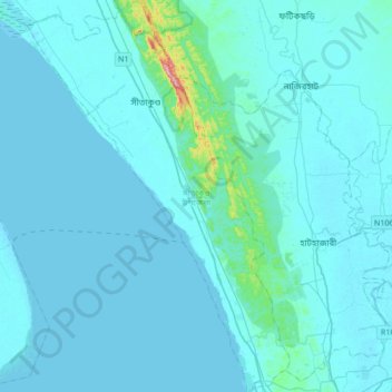
Name: Sitakunda Upazila topographic map, elevation, terrain.
Average elevation: 49 ft
Minimum elevation: -3 ft
Maximum elevation: 997 ft
Make a donation
Gear up for your next adventure:
As an Amazon Associate, this site earns from qualifying purchases at no extra cost to you.
Other topographic maps
Click on a map to view its topography, its elevation and its terrain.
Rangamati
Bangladesh > Chattogram Division > Rangamati Sadar Upazila
Rangamati (Bengali: রাঙ্গামাটি;) is the administrative headquarter and town of Rangamati Hill District in the Chittagong Hill Tracts of Bangladesh. The town is located at 22°37'60N 92°12'0E and has an altitude of 14 metres (46 ft).
Average elevation: 223 ft
Make a donation
Gear up for your next adventure:
As an Amazon Associate, this site earns from qualifying purchases at no extra cost to you.
Rajeshpur Eco-Park
Bangladesh > Chattogram Division > Cumilla Adarsha Sadar Upazila
Average elevation: 49 ft
Make a donation
Gear up for your next adventure:
As an Amazon Associate, this site earns from qualifying purchases at no extra cost to you.
Make a donation
Gear up for your next adventure:
As an Amazon Associate, this site earns from qualifying purchases at no extra cost to you.
Make a donation
Gear up for your next adventure:
As an Amazon Associate, this site earns from qualifying purchases at no extra cost to you.
Darjeling para
Bangladesh > Chattogram Division > Bandarban District > Darjeling para
Average elevation: 2,021 ft
Keokradong
Bangladesh > Chattogram Division > Bandarban District > Darjeling para
Average elevation: 2,451 ft
Sonadia Island
Bangladesh > Chattogram Division > Cox's Bazar District > Poschim para > Sonadia Island
Average elevation: 3 ft
Make a donation
Gear up for your next adventure:
As an Amazon Associate, this site earns from qualifying purchases at no extra cost to you.