Geolocate

Remedios topographic map

Click on the map to display elevation.

About this map

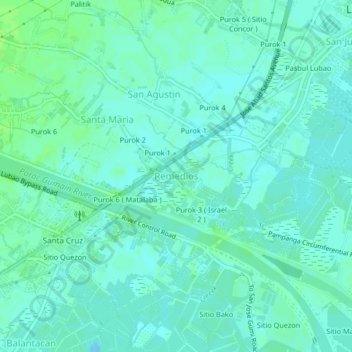
Name: Remedios topographic map, elevation, terrain.

Location: Remedios, Lubao, Pampanga, Central Luzon, 2005, Philippines (14.89881 120.55864 14.93881 120.59864)

Average elevation: 13 ft

Minimum elevation: 0 ft

Maximum elevation: 33 ft

Other topographic maps

Click on a map to view its topography, its elevation and its terrain.

Batasan River

Philippines > Pampanga > Lubao > Santa Teresa 2nd

Average elevation: 13 ft

Gear up for your next adventure:

🌐World Map Poster - Decorative world maps with topographic info
🌧️Backpack Rain Cover - Keep gear dry in wet weather
🪑Portable Camp Table - Compact table for campsite meals
🎁Geography Themed Gifts - Unique gift ideas for map lovers and geography enthusiasts
🔋Rechargeable Batteries - Power up your outdoor devices

As an Amazon Associate, this site earns from qualifying purchases at no extra cost to you.