Geolocate

Cambridge City topographic map

Click on the map to display elevation.

About this map

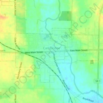
Name: Cambridge City topographic map, elevation, terrain.

Location: Cambridge City, Wayne County, Indiana, United States (39.80446 -85.18352 39.82070 -85.15471)

Average elevation: 958 ft

Minimum elevation: 912 ft

Maximum elevation: 1,017 ft

Wayne County trails, hiking, mountain biking, running and outdoor activities

Other topographic maps

Click on a map to view its topography, its elevation and its terrain.

East Germantown

United States > Indiana > Wayne County > Pershing

Average elevation: 955 ft

Gear up for your next adventure:

🛰️Handheld GPS Units - Professional satellite navigators for precise backcountry mapping
📱Heavy-Duty Phone Cases - Drop-proof and waterproof protection for outdoor navigation
🪄Magnetic Compass - Accurate compass for navigation
🛡️Bear Spray Outdoor - Protection in bear country hikes
🪶Fire Starter Kit - Reliable fire starter for survival and camping

As an Amazon Associate, this site earns from qualifying purchases at no extra cost to you.